Product Download
Satellite data, corresponding to the
gridding scheme, are available from this page in HDF format. The files have been
compressed using bzip2, which is freely availabe for most operating
systems from here (note:
it will already be installed by default on most Linux systems).
There are files to read the data into IDL or MatLAB available from further down this page. To use the IDL scripts ensure you are in the directory containing the data file then type @filename.idl at the IDL prompt. The MatLAB files can be used by typing 'filename' at the MatLAB prompt.
HDF Data Files
ISAMS Direct Measurements
This file contains the following variables and dimensions:
- Extinction (Time, Longitude, Latitude, Altitude, Channel)
- Extinction Error (Time, Longitude, Latitude, Altitude, Channel)
- Time
- Longitude
- Latitude
- Altitude
- Channel
POAM II Direct Measurements
This file contains the following variables and dimensions:
- Extinction (Time, Longitude, Latitude, Altitude)
- Extinction Error (Time, Longitude, Latitude, Altitude)
- Time
- Longitude
- Latitude
- Altitude
SAGE I Direct Measurements
This file contains the following variables and dimensions:
- Extinction (Time, Longitude, Latitude, Altitude, Channel)
- Extinction Error (Time, Longitude, Latitude, Altitude, Channel)
- Time
- Longitude
- Latitude
- Altitude
- Channel
SAGE II Direct Measurements
This file contains the following variables and dimensions:
- Extinction (Time, Longitude, Latitude, Altitude, Channel)
- Extinction Error (Time, Longitude, Latitude, Altitude, Channel)
- Temperature (Time, Longitude, Latitude, Altitude)
- H2O Mixing Ratio (Time, Longitude, Latitude, Altitude)
- H2O Mixing Ratio Error (Time, Longitude, Latitude, Altitude)
- Time
- Longitude
- Latitude
- Altitude
- Channel
SAGE II Cloud Cleared Measurements
This file contains the following variables and dimensions:
- Extinction (Time, Longitude, Latitude, Altitude, Channel)
- Extinction Error (Time, Longitude, Latitude, Altitude, Channel)
- Temperature (Time, Longitude, Latitude, Altitude)
- H2O Mixing Ratio (Time, Longitude, Latitude, Altitude)
- H2O Mixing Ratio Error (Time, Longitude, Latitude, Altitude)
- Time
- Longitude
- Latitude
- Altitude
- Channel
SAGE II AOPP Algorithm
This file contains the following variables and dimensions:
- Effective Radius (Time, Longitude, Latitude, Altitude)
- Effective Radius Error (Time, Longitude, Latitude, Altitude)
- Surface Density (Time, Longitude, Latitude, Altitude)
- Surface Density Error (Time, Longitude, Latitude, Altitude)
- Volume Density (Time, Longitude, Latitude, Altitude)
- Volume Density Error (Time, Longitude, Latitude, Altitude)
- Number Density (Time, Longitude, Latitude, Altitude)
- Mode Radius (Time, Longitude, Latitude, Altitude)
- Spread (Time, Longitude, Latitude, Altitude)
- Time
- Longitude
- Latitude
- Altitude
SAGE II Effective Radius
This file contains the following variables and dimensions:
- Effective Radius (Time, Longitude, Latitude, Altitude)
- Effective Radius Error (Time, Longitude, Latitude, Altitude)
- Time
- Longitude
- Latitude
- Altitude
SAGE II Surface Area Density
This file contains the following variables and dimensions:
- Surface Area Density (Time, Longitude, Latitude, Altitude)
- Surface Error Area Density Error (Time, Longitude, Latitude, Altitude)
- Time
- Longitude
- Latitude
- Altitude
SAGE II Composition
This file contains the following variables and dimensions:
- H2SO4 weight fraction (Time, Longitude, Latitude, Altitude)
- Time
- Longitude
- Latitude
- Altitude
SAGE III Direct Measurements
This file contains the following variables and dimensions:
- Extinction (Time, Longitude, Latitude, Altitude, Channel)
- Extinction Error (Time, Longitude, Latitude, Altitude, Channel)
- Time
- Longitude
- Latitude
- Altitude
- Channel
SAM II Direct Measurements
This file contains the following variables and dimensions:
- Extinction (Time, Longitude, Latitude, Altitude)
- Extinction Error (Time, Longitude, Latitude, Altitude)
- Time
- Longitude
- Latitude
- Altitude
Corresponding IDL and MatLAB Load Files
ISAMS Direct Measurements IDL or MatLAB
POAM II Direct Measurements IDL or MatLAB
SAGE I Direct Measurements IDL
SAGE II Direct Measurements IDL or MatLAB
SAGE II Cloud Cleared Measurements IDL or MatLAB
SAGE II AOPP Algorithm IDL or MatLAB
SAGE II Effective Radius IDL or MatLAB
SAGE II Surface Area Density IDL or MatLAB
SAGE II Composition IDL or MatLAB
SAGE III Direct Measurements IDL or MatLAB
SAM II Direct Measurements IDL or MatLAB
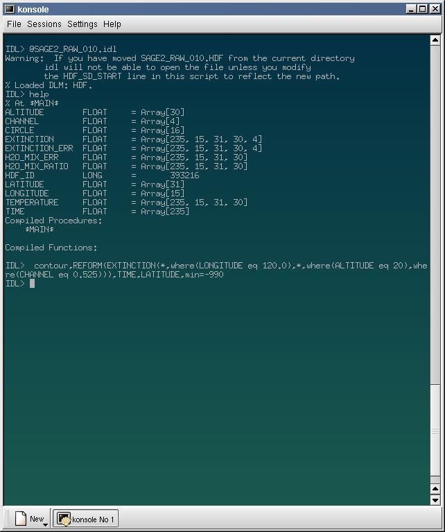
The following image is a screen capture showing the loading of SAGE II RAW direct measurement data into IDL using the supplied IDL load file.
The HELP command shows a listing of imported variables.
I have then performed a contour plot of extinction values at 20 km altitude and 120 deg longitude for the 0.525 um channel.
Gareth Thomas
Last modified: Tue Nov 30 13:05:50 BST 2004