 |
 |
 |
 |
 |
 |
 |
 |
 |
|||
 |
|
||||||||||
|
|
|
|
|
|
|
|
|
|||
|
|
||||||||||
Satellite InstrumentsOur Earth observation research mainly uses two types of instrument:
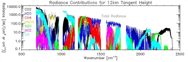
A trend in remote sensing has been towards instruments that work at very high spectral resolution (typically < 0.1 cm-1 in the infrared). To achieve high specral definition we use a sophisticated version of a Michelson interferometer common in undergraduate physics laboratories. This instrument uses the interference of light to measure the interference function of incoming light. The basis of the technique is the Fourier-pair relationship between the interferogram (interference function) of a substance and its spectrum. The radiance at the top of the atmosphere at infrared wavelengths is comprised of both emission from the Earth's surface and emission from the atmosphere. By using a high resolution instrument to measure this radiance it is possible to discern emission bands or even emission lines associated with discrete changes in a particular gas's change in rotation and vibration. While the broad shape of the spectrum can be used to infer aerosol, cloud and even surface properties our main use of high-resolution EO data is to determine atmospheric gas concentrations of species such as SO2, NH3, OCS and HCN. The instruments that we use are:
A radiometer is a device used to measure the intensity of radiant energy. Nadir viewing satellite radiometers measure the top-of-atmospheric radiance over a small region of the electromagnetic spectrum, typically 10 μm in the shortwave and 50 cm-1 in the infrared. This bandwidth is too wide to discern individual gas emission lines so top-of-atmospheric radiometer measurements are dominated
By using a scan mirror an imaging radiometer can construct an image of the sub satellite view. Optics within an instrument can split the light from each picture element (or pixel) into several wavebands to form collocated multi-spectral images. Such multi-spectral imaging radiometer measurements are used by the Optimal Retrieval of Aerosol and Cloud (ORAC) algorithm to estimate climate-relevant surface and atmospheric properties such as
ORAC was developed by the EODG in conjunction with scientists at the Rutherford Appleton Laboratory. The space-based radiometers we use in much of our research include:
and for fun ...TIROS-NENVISATIASI (no sound) |
||||||
| Earth Observation Data Group, Department of Physics, University of Oxford. | Page last updated: @20:39 GMT 15-Jun-2026 | |||||